

gmt
-
Content Count
377 -
Joined
-
Last visited
Posts posted by gmt
-
-
-
may I quote myself here:
c5 galaxy vs c130 hercules...

feel free to klick the links and see for yourself...
-
Pretty likely to be an AC-130 look a like (upper right corner).
or it could be C5 galaxy, because the nose of the AC-130 its too short.
BTW really could airplane.
c5 galaxy vs c130 hercules...
-
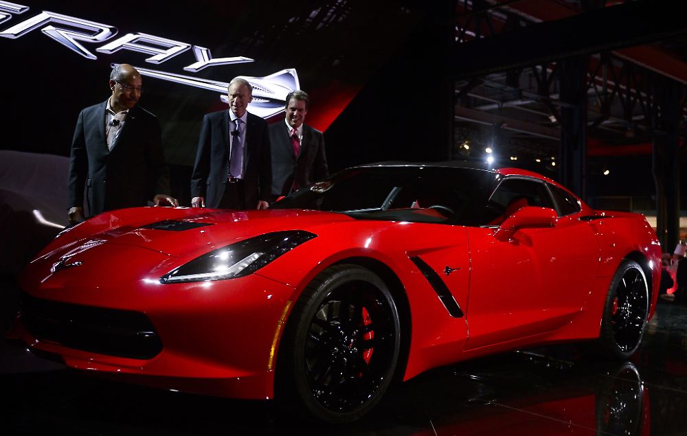
I think there's also a lot of the Corvette C7 that was just revealed at the NAIAS in the red car... at least more of a C7 than a 458 Italia...
I know the final C7 is younger than the red car and the early concept of the C7 was seen in Transformers and quite different, but who knows how many design studies have leaked into the interwebs during production that R* could have seen gathering resources for the vehicle creation
-
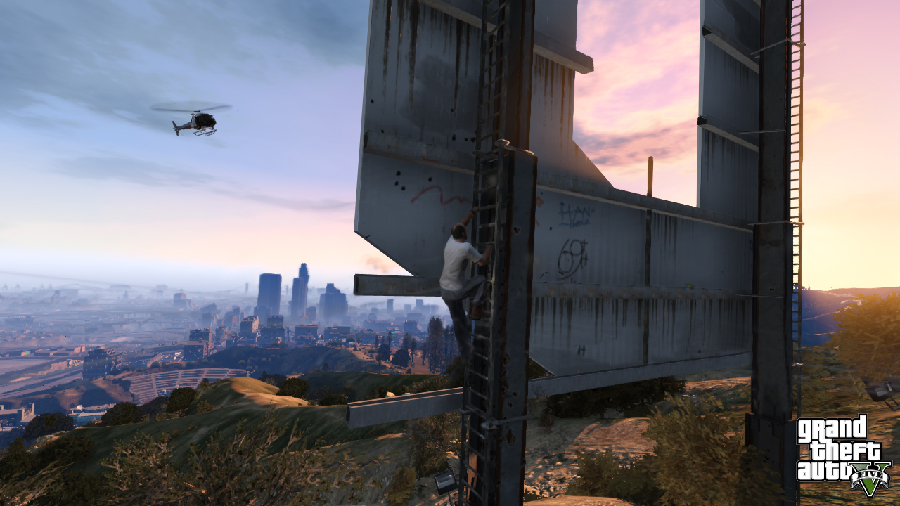
if you can add 1+1, you'd realize how the Vinewood sign MUST be covered behind his leg, at leat partially, and you can't see it becaue of the photo was taken "into" the light.
you can see R*s take on both the Roosevelt and First National Bank in both screenshots form more or less the same perspective.
what bothers me more is how much the mountain in the back shifts from just a little angular change in perspective, which most likely means it's considerably close to the Vinewood Hills which, in turn, doesn't speak in favor of a large map...
-
 1
1
-
-
What if Grapeseed was the area where the vineyards are, rather than a farming town? I mean, it would make sense name-wise?
I've assumed that the entire time. If anything a few normal farms/orchards probably border the vineyard or are included in the same area.
I think R* labled the entire argricultural area of the map Grapeseed, so it's more like Grapeseed County rather than just a single town of that name (not saying there won't be a town of Grapeseed).
Would make sense since the screenshot obviously shows nothing but farming, while the name hints on vineyards.
There's quite some farming in the vicinity of Oxnard, not too far away to sound like a plausible part of an argricultural scenery if we place the vineyards in the Malibu area
-
Aside from the headlights there isn't much else in common.
Aaaand it's red. red. red like a real michael schumacher ferrari.
fair enough to qualify for a 458
-
looks like nobody has pointed that out yet
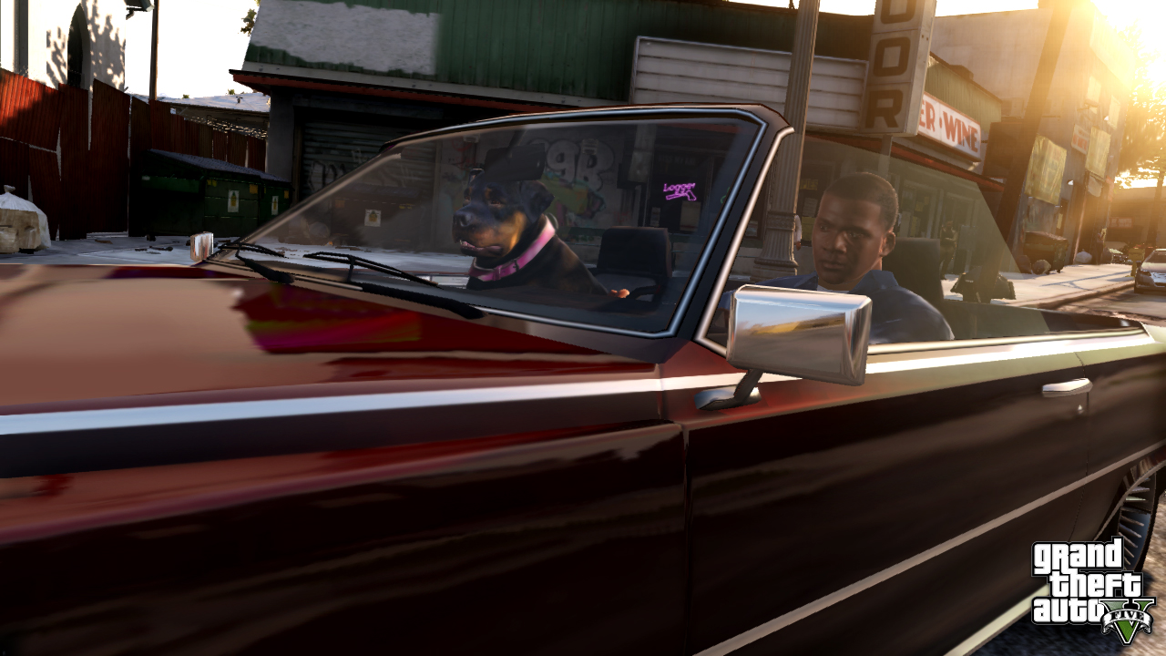
well in this screenshot the car at the right, the front looks pretty much like a 2006 Volkswagen Passat to me
-
1
-
-
/\
just what I was talking about concerning map shape ignoring geography...
-
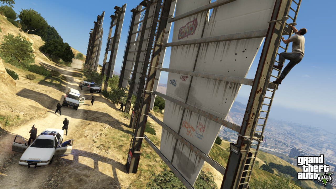
I'd call this yet another sign of the map being still a WIP while campainging for the game.
if you take this screenshot and find Centennial Mills (just below the left end of Gerald Desmond Bridge) and now comapare the whole area up to the coast with the same are in this screenshot (easy as Centennial Mills kinda leap out of the scenery concerned), you can see how they stretched the harbor area - at least that's what I think it is, GD Bridge is part of the LA harbor infrastructure and the constructions concerned look like harbor cranes to me; what else should such structures right at the coast be? - to the left and also changed a bit of the coastline, the 2nd screen shows a remarkable dent (try to spot it between the bars of the ladder) that I think should be visible in the 1st screen aswell, if it was there.
EDIT: 1 in a million moment, I felt like drawing a pic:
green the coastline, orange the structures... and while creating this masterpiece of contemporary art, I realized how much more detailed the area to the left of Centennial Mills is in the 2nd pic, so changes not just happened at the coast...
-
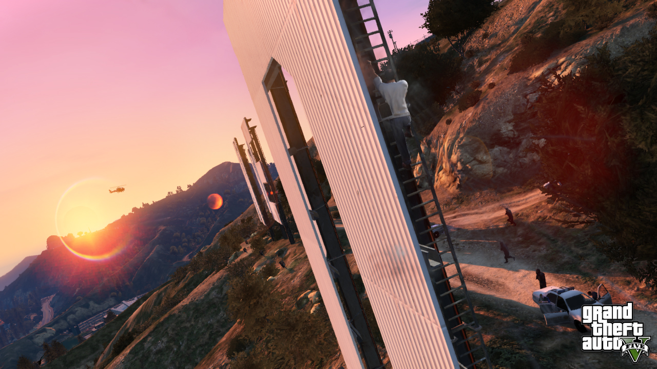
You're right, but the change of perspective doesn't explain the change of location. Especially compare the 2nd and 3rd screenshot I linked, in both screens Trevor climbs the "D" and the camera just rotates at couple feet distance around the scene, imho quite obvious that the change of perspective does not account for the change of location relative to the Vinewood sign.
The Bowl is located about straight south of the "D" in the 2nd screenshot and in the 3rd, it's pretty much straight to the west of the sign.
Of course I'm assuming it's the same structure that just changed location during development.
It might aswell be a totally different venue from the Bowl; theres also the Greek Theatre just a quarter mile east of the Observatory irl, but tbh I don't think R* includes both of them as the Greek Theatre is just not as famous as the Bowl
-
leaving my map shape hickup aside for a sec, I was comparing Vinewood-sign screenshots (tried to put some figures to scale estimations based on the size of the Hollywood sign) and now wonder how much R* fiddles with the map even at a late state of development.
the "new" screenshot shows some Hollywood Bowl like structure somewhat south of the Vinewood sign, partially covered by the gta logo.
in an older screen of Trevor climbing the D, the same structure is more or lessat the same spot, some prominent features like the trident-idh clamshell roof can be seen.
now, back as we identified this thing as the Hollywood Bowl, this screen cleary showed the structure in between the Vinewood sign and the Observatory.
-
why do almost all map estimations ignore the actual geography of the area concerned?
am I the only one who thinks that R* will continue the trend of considering the real life geography of the cities involved?
I know I said this already, but when I look at how the geographical accuracy evolved since III, I have a hard time thinking of a V with a totally random landscape design.
III era LC was a very very vague take at NYC, then VC was still vague but with improved accuracy, then SA came with already a lot of accuracy concerning the city shapes aswell as the main geography in between them.
with IV there was a huge step, representing a lot of NYC's actual geography.
judging from what we've seen of Los Santos itself, it seems R* stays at least on the same level of accuracy they used in IV, so why does it seem like barely any of the fan-made maps consider this trend when it comes to the surrounding landscape?
don't get me wrong, I appreciate the efforts and ideas put into those maps and there's a lot of nice maps out there - no matter how likely they are - but most of them seem to more or less ignore the actual socal geography
-
I think Pud's right with the location of Grapeseed.
when you look closer to the right of the highway picture, just behind the power pole is the 3rd mountain visible all to the left of the grapeseed picture.
certainly to the west of the highway/prison/desert airstrip area
-
http://uk.gamespot.c...-report-6401593
Probably nothing but at least it gives the fanboys something to fap over.
*Jizzes for no reasons*
That would make GTA V's map look dwarf. It would probably take 10 years to create, unless they double the development team and production budget (Which they probably could/would knowing R*'s passion for games)
when I saw these news earlier today, my first thought with all these anniversary releases in mind, was to give III and VC a technical revision and pair it with SA. most ppl jizz anyways when they here VC and SA. And considering the small visit to III era LC in SA, why not.
even current gen consoles would be able to handle a combined III era world rendered to SA's quality.
for a whole new, state of the art GTA game of these dimensions, I fear we're downloading for weeks or get to swap blurays back and forth a trillion times
But that's totally off topic in this thread anyways
-
that is probably the other side of this picture
with this one as well
Since he's climbing the D in the first pictures and the V in the new one here, looks like Trevor's got a lotta business at these letters... maybe learning to write or something.
-
I wonder where all the fuzz about a damn ingame-phone/it service comes from?
Nobody cared about phones prior to the release of IV and even after that interest in it was considerably low.
but now? Just because it's clearly a hint on apple? really?
Anways, I doubt it'll be anything more special than it was in IV, at best I can think of the game's menu being linked into the device, similar to saints row 3.
and pc / notebooks will just offer as much as they did in IV, so they'll basically fall off behind the train unless you gotta use them to date a gay prick talking shit about your nightclub
-
could be snow, could be blank rock... in the buggy scene of the trailer, there's very small hills with blank rock almost the same color, none of the large mountains in the 2nd trailer has visible snow, but in the 1st trailer's hiking scene, there's plenty of blank rock.
Got a question concerning the cuban 800 takeoff-scene...
very last frame, lefthand border, are these far away highrises or nearby silos?
-
I have a doubt, a huge doubt. Where this highway goes? It starts in Los Santos, but where it goes?
a highway doesn't just stop they connect cities but there only is one thats what he means
i think it just rings around the whole map from the bottom of Los Santos around then to the top of LS
anyone used the windmills in that pic for mapping?
I did and I think fitty and or dup also figured out.
In the highway scene, we are looking towards LS from the area where the skydiving jeep scene happens.
Noone can say for sure tho where the highway comes from. Both the map-looping highway as well as the outfading highway scenario are possible, but it could also lead towards another town and stop as (under construction) after the junction.
There is definitely trolleys, im not sure about a subway, i dont think los angelos has one..
LA has two subway lines, 3 light rails and even one elevated light rail. we've seen one of the light rails already and chances are we also get some subway or at least some underground station to any of the rails, something like Market Station in SA.
-
at least it doesn't sound like its going to be the way it was in San Andreas where the immideate coast was modeled and everything beyond was just ground texture and water...^ That's exactly what I would expect it to be, maybe a larger detailed underwater area than SA had, but I can't see them throwing away disc space on the edges of the map.
procedural generation is the magic concerned.
you barely "waste" anything and still can create immense things.
just think of minecraft, the core files are just a couple of mb and yet each time a world is started, they generate the biggest game environment these days, covering a larger area than the surface of the earth.
thats where I was going with my post.
all the scenery-relevant data is there already in the game; water, ground textures, plants, rocks, animals, effects like dust or splashing waves... all you need to do is add a code that randomly mixes it over and over again to procedurally generate an endless world beyond the actual map.
now I'm no expert when it comes to coding, I learned basic in school (at a time when c++ and .net have been established already, go figure) and taught myself some smallscale html and c++, but I have a hard time thinking that'll be a waste of disc space to implement a procedurally generated endlessness beyond the actual map when using visual content already present, which would make sense to make transitions smooth
anyways, I think we won't have an endless desert, I hink we'll have a large island to play with and and endless ocean around to get lost forever, either with or without detailed ocean floor, but I think it's with. a procedurally generated endless oceanfloor works in just cause 2 (at least as far as my experiments can tell), why shouldn't it work here?
-
Still think it would take up more resources than just sea, could be wrong though.
since R* said they detailed the ocean floor aswell, I don't think there's too much of a difference between endless desert and endless ocean around the map.
at least it doesn't sound like its going to be the way it was in San Andreas where the immideate coast was modeled and everything beyond was just ground texture and water...
basically, the only thing they have to do is write a bunch of lines of code to create the generator (or implement one of the many random generators into the game's code), everything else that's needed to create a seemless transition from the real map and a believable endless ocean/desert/forrest/whatever (textures, models, effects) is already in the game anyway.
-
Put this together in SketchUp. Lots of guesswork in parts obviously but I tried to match all the pictures.
Added a link to the file: you'll need sketchup to look at it.
I really love the 3d-take on the map and appreciate the effort you put into figuring it out.
But I'm honest, I don't like the shape... well no, I like it as such, but it doesn't feel right to me.
Because, when I think how more or less accurate San Andreas was in terms of geographic features - even tho a lot of things were very scatchy, imrovised and off, many many things were about accurate - and then think of how the map creation evolved in IV and how much more accurate LC was to it's real life counterpart compared to SA - and IV was considerably accurate concerning the shape and geography of NYC - I think R* continues this trend and stays at least as accurate as they were in IV, if not enhance it another shade or two.
again, I like your map and appreciate the effort, but I think V's map will be much more geographically accurate as your idea of the map; of course not scale accurate but enough accuracy to identify the location on first sight just looking at the outlines of the map
-
From Game Informer's Q&A:
From what you saw, did Los Santos, the city itself (not including mountains/countryside/etc.) appear bigger than GTA IV’s Liberty City?Los Santos definitely covers more square footage, just as the sprawling Los Angeles metro area does compared to New York City. But just like the real cities, if you’re wondering about the density of the downtown area, Los Santos proper is smaller than Liberty City.
http://www.gameinfor...PostPageIndex=2
Aaaand... go.
I slowly start to feel like R* condemned the magazines to not be precise about the size of the map.
no other explanation for all the different and vague statements
-
Yep, That's it. And to the top left of that screenshot beside the tall white tower, is Rockford hills aka Micheal's house location.
among the things I pointed out 2 days ago, but seems it got lost between all the picture-laden posts...
nevertheless, you're absolutely right, that's exactly where Michael's house is, in this picture behind what's supposed to be 9200 Sunset (the one with the crane opposite Sierra Towers)
EDIT
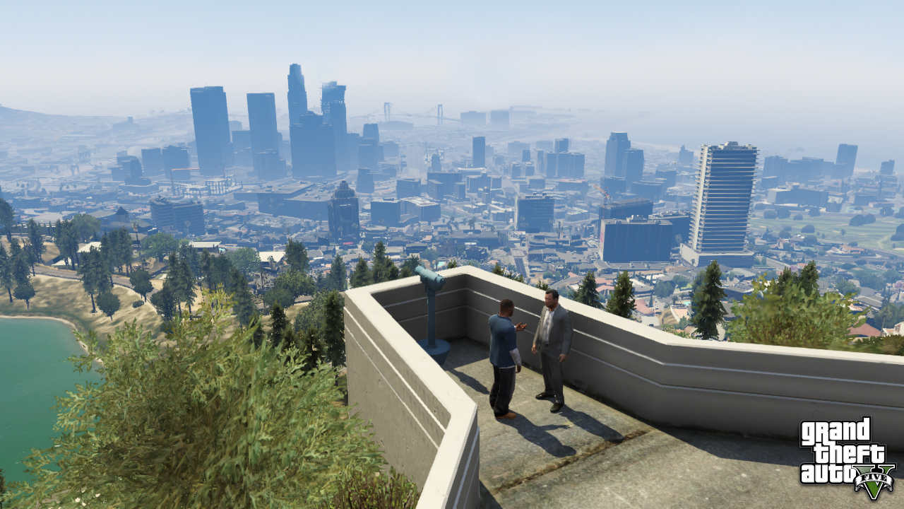
I think the lake in this shot could be R*s take on the Hollywood Reservoir.
at least there's no other body of water worth mentioning in the hills and the vicinity of the observatory.
and - contrary to what IGN writes - I'm sure this is not the same lake we've seen in the first 2 screenshots released which we identified as R*s take on Echo Park, just nothing matches... curvy lakefront, no paved paths right at the water, no houses, just trees and definitely not on more or less at the same elevation as downtown


GTA V Vehicles Seen - Returning and New
in GTA 5 Pre-Release Discussion (Closed)
Posted · Report reply
AN 225?
almost missed that one..
this is getting better by the minute!
Ok, let me make an equally educated guess: the big plane is clearly a classic battlestar, maybe the atlantia...